In the wee hours of New Year’s Day, 2011, while many Americans were celebrating the beginning of a new year, portions of the Southeastern U.S. were being pummeled by a series of violent tornadoes.
During the first three hours of this year, seven confirmed tornadoes touched down in the state of Mississippi, leaving behind a path of devastation and destruction and kicking off what would become one of the most active tornado seasons in U.S. history.
According to the National Weather Service, over a thousand confirmed tornadoes touched down within the first five months of 2011, causing an estimated $20 million in damage.
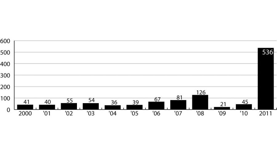
National Weather Service statistics revealed that 60 of this year’s twisters were “killer tornadoes,” causing not only severe property damage but also tragic loss of life. At least 536 people died in the United States this year as a result of these deadly tornadoes. This number appears especially large when compared to 45 fatalities in 2010 and just 21 deaths in 2009.
The April 27 tornadoes, referred to as the “Dixie Outbreak” by the National Weather Service, claimed the lives of at least 335 people and now hold the record for deadliest tornado day (midnight to midnight) in modern history.
There are many possibilities for the increased number of tornadoes this year, said Richard Scott, WVUA’s chief meteorologist.
“The jet stream has been stronger than normal this year due to a colder than normal air mass to the north and warmer than normal air mass to the south,” Scott said.
A jet stream is a thin, narrow band of wind in the upper atmosphere, according to the National Weather Service. Jet stream winds often reach 100 to 200 miles per hour on a daily basis. These bands of air have great implications on weather conditions in the lower atmosphere.
“A stronger jet creates stronger wind shear and provides a stronger lift for storms,” Scott said.
Although most people would likely agree that the slower than usual hurricane season last year is a good thing, Scott said he believes it could be a contributing factor to the high number of tornadoes across the southeast this year.
“The Gulf of Mexico is warmer than normal due to the lack of hurricanes last year in the gulf,” he said. “Usually, several hurricanes track across the gulf and upwelling cools the gulf temperature a bit. Without that process last year, the gulf stayed warmer than usual.”
Often, higher than normal hurricane or tornado seasons that continue for several years are related to weather patterns, Scott said.
“[Severe weather conditions] could be related to the lack of pattern change,” Scott said. “Or, this could be related to a La Niña or El Niño pattern, which often sticks around for several years. These patterns can become a culprit for drought in the deep south or flooding over periods of months and years.”
Meteorologists, like Scott, use various tools and sources of data to attempt to predict and understand tornadoes and other storm patterns.
“There are lots of tools we use to forecast the weather in the short term and long term,” Scott said. “As for the short and long term, we have lots of computer data we can look at that gives us a guide to what type of weather we can expect.”
Meteorologists use data about recent and historic weather patterns to help them understand current weather phenomena.
“We also look at past patterns – as in, what’s been the key factor over the past few days, weeks and months – or historical data, such as what type of weather we often see in a pattern like the one we’re in right now,” he said.
Even with all the technology available to meteorologists, it is still hard to predict weather patterns since they are constantly changing.
“I think it’s a wonder that we are able to figure out the weather this afternoon, much less seven days out,” he said. “Data changes, and we must roll with the punches to figure out what our weather is going to do.”
Tornado fatalities in U.S. by year:
2011: 536
2010: 45
2008: 21
2007: 81
2006: 67
2005: 39
2004: 36
2003: 54
2002: 55
2001: 40
2000: 41
Source: National Weather Service


