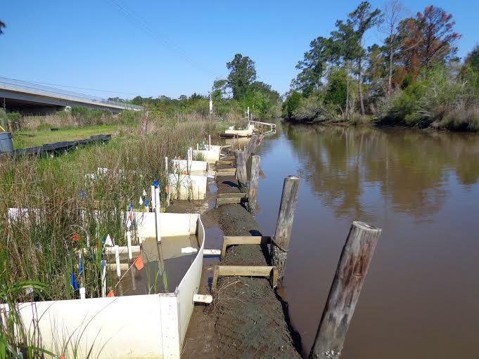
Julia Cherry, an associate professor with the University’s New College and its biological sciences department, used grant money to conduct the study in 2013 and 2014 with a team of researchers. The research is ongoing.
The research was conducted at the Weeks Bay National Estuarine Research Reserve on the eastern shore of Mobile Bay in Baldwin County. National Estuarine Research Reserve Systems Science Collaborative, which funds people to partner with their reserve system on projects of interest, funded the program. The main concern of the project focused on how to protect coastal ecosystems from rising sea levels. Using the weirs, the team was able to mimic rising sea levels that previously proved difficult to replicate.
“For this particular aspect of the project, knowing that these marshes are facing the threat of sea level rise, it’s really important to try and understand processes involved in the marshes themselves and how those processes might change as they are flooded more and more frequently by rising seas,” Cherry said. “And to do that experimentally, you need to be able to manipulate water levels, and it’s hard to do that in the marsh, so typically what scientists have done is use what we like to call mesocosms.”
The mesocosms Cherry refers to are bucket-type approaches, where marsh can be dug up and taken to a greenhouse to be flooded.
Due to the small-scale aspect of the mesocosms, there were certain things unable to be measured, so the team took the research to the field.
“Instead of taking the marsh somewhere else, we wanted to take the experiment to the marsh,” Cherry said.
Eric Sparks, who was a post-doctoral researcher and the project manager at the time of the research, who is currently assistant extension professor at Mississippi State University, believes that with this “new methodology”, researchers will better understand management techniques for the conservation of vital wetlands.
“The most important thing from my point of view is this new methodology allows you to evaluate the effects of sea level rise on much larger scales, which somewhat reduces the error associated with measurements on smaller scales in the past,” Sparks said.


